A mesocyclone is a vortex of air within a convective storm.It is air that rises and rotates around a vertical axis, usually in the same direction as low pressure systems in a given hemisphere. They are most often cyclonic, that is, associated with a localized low-pressure region within a severe thunderstorm. Such thunderstorms can feature strong surface winds and severe hail. Mesocyclones often occur together with updrafts in supercells, within which tornadoes may form at the interchange with certain downdrafts.
Mesocyclones are localized, approximately 2 km (1.2 mi) to 10 km (6.2 mi) in diameter within strong thunderstorms. Thunderstorms containing persistent mesocyclones are supercell thunderstorms. Mesocyclones occur on the "mesoscale", a more general term used in meteorology to denote organization on scales from a few up to hundreds of kilometers. Doppler radar is used to identify mesocyclones. A mesovortex is a similar but typically smaller and weaker rotational feature associated with squall lines.
Mesocyclones are localized, approximately 2 km (1.2 mi) to 10 km (6.2 mi) in diameter within strong thunderstorms. Thunderstorms containing persistent mesocyclones are supercell thunderstorms. Mesocyclones occur on the "mesoscale", a more general term used in meteorology to denote organization on scales from a few up to hundreds of kilometers. Doppler radar is used to identify mesocyclones. A mesovortex is a similar but typically smaller and weaker rotational feature associated with squall lines.
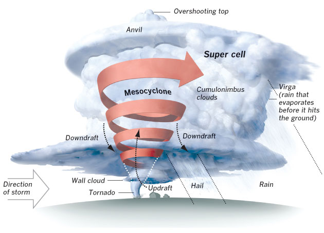
Image Credit: http://zoomradar.com/brandon/tornadoes/
A Mesocyclone is tilted and stretched due to the directional and speed shear evident, its diameter decreases and Rotation increases. It analogous to a figure skater pulling her arms closer to her body speeding up her rotation. Finally as speed increases, pressures increase toward the surface.
As a Mesocyclone develops and intensifies it may produce a Wall Cloud. A Wall Cloud hangs below the rain free base or cloud base. The wall cloud forms from rapid convergence of inflowing air called INFLOW.
A funnel cloud will originate from the wall cloud. The funnel cloud will connect with the updrafts from the occlusion front, where strong updrafts are present from where the cold front caught up with the warmfront and has lifted it. It becomes a tornado once the connection with the ground is complete.
